Buffalo National River
Fast Facts
Buffalo National River
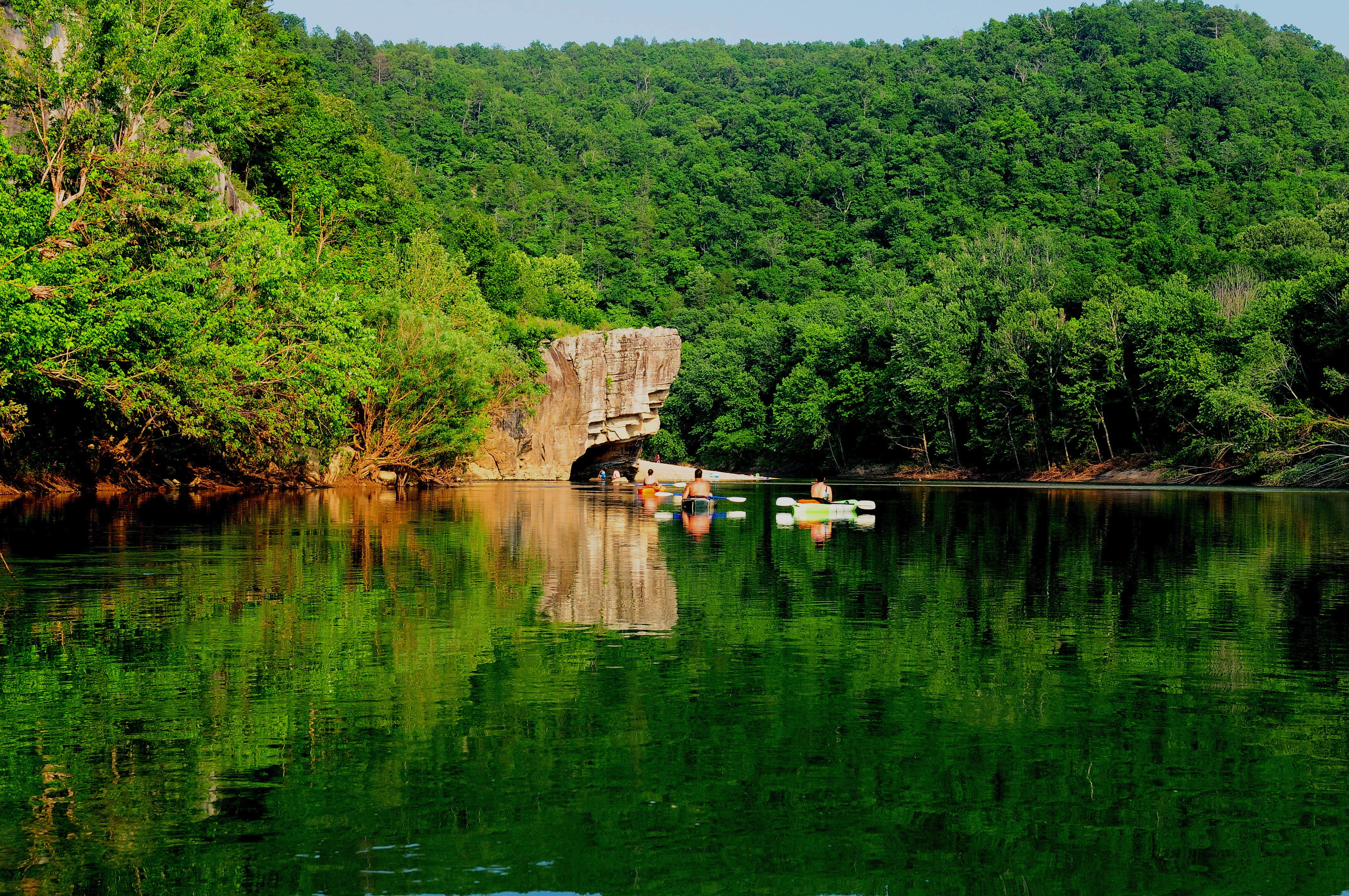
Deep in the rugged and ancient landscape of the Arkansas Ozarks, the Buffalo National River preserves one of the most spectacular and ecologically healthy waterways in the United States. Established in 1972 as America's first national river, the Buffalo flows freely for 135 miles, making it one of the few remaining undammed rivers in the lower 48 states. It is a landscape of vertical drama, defined by the massive limestone bluffs—some rising over 500 feet—that dwarf the paddlers and anglers who navigate its emerald-green waters. From its high-elevation headwaters in the Boston Mountains to its confluence with the White River, the Buffalo is a study in natural resilience and timeless beauty.
The river corridor encompasses over 95,000 acres of protected land, offering a sanctuary for a diverse range of wildlife and the preservation of a unique mountain culture. The Buffalo is home to Arkansas's only elk herd, which can frequently be seen grazing in the meadows of the Boxley Valley. The surrounding forests of oak, hickory, and pine provide a lush backdrop for the river's alternating sequence of rushing rapids and quiet, deep pools. Beyond its natural wonders, the park protects numerous historic sites, including pioneer homesteads and ancient bluff shelters, that tell the 10,000-year story of human adaptation to this karst-defined landscape.
Visiting the Buffalo National River is an invitation to immerse yourself in the rhythms of the Ozarks. Whether you are navigating the challenging "Big Buffalo" rapids of the upper river, exploring the labyrinthine passages of the Indian Rockhouse cave, or simply watching the fog lift off the water at dawn from a remote gravel bar campsite, the park provides a profound sense of wildness. It is a place where the sounds of the rushing water and the calls of the barred owl are the only constant, and where the connection between the land and the river remains unbroken.
Key Highlights
- Massive Limestone Bluffs: Witness the "Sentinels of the Buffalo," sheer rock faces like Big Bluff and Roark Bluff that provide some of the most iconic scenery in the Ozarks.
- World-Class Paddling: Navigate 135 miles of free-flowing water, offering everything from technical whitewater in the Upper District to leisurely floats in the Lower District.
- Elk Viewing in Boxley Valley: Spot the majestic Ponca elk herd in the expansive meadows of the Upper Buffalo, especially active during the fall rutting season.
- The Indian Rockhouse: Hike to one of the largest and most spectacular bluff shelters in the region, featuring unique geological formations and evidence of prehistoric use.
- Historic Homesteads: Explore the remains of 19th-century mountain life at the Sod Collier and Parker-Hickman farmsteads, preserved as windows into Ozark history.
- Gravel Bar Camping: Experience the ultimate in river solitude by spending the night on a natural gravel bar under the dark night skies of the Buffalo corridor.
- Smallmouth Bass Fishing: Cast a line into one of the premier smallmouth bass fisheries in the country, known for its clear water and productive structure.
Getting There
Buffalo National River is a long, narrow park that spans across four counties in northern Arkansas. Because of its linear geography, there are three primary districts, each with its own access points.
Upper District (Ponca/Boxley):
- By Car: Accessed via Arkansas Highway 43 and Highway 74. Ponca and Boxley are the primary hubs for those looking to float the upper reaches of the river or view the elk herd.
- Main Access: The Steel Creek and Kyle’s Landing areas are popular entry points for the Upper Buffalo.
Middle District (Tyler Bend/St. Joe):
- By Car: Accessed via U.S. Highway 65 and Arkansas Highway 333. Tyler Bend is the park’s primary administrative hub and features the largest visitor center.
- Visitor Center: The Tyler Bend Visitor Center is located at 170 Ranger Road, St. Joe, AR 72675.
Lower District (Buffalo Point/Rush):
- By Car: Accessed via Arkansas Highway 14 and Highway 268. Buffalo Point is the most developed area of the park and was formerly an Arkansas State Park.
- Main Access: Buffalo Point features a seasonal contact station and easy access to the river and the historic Rush Mining District.
Nearest Airports:
- Boone County Airport (HRO): Located in Harrison, AR, approximately 20-40 minutes from the Upper and Middle Districts.
- Northwest Arkansas National Airport (XNA): Approximately 1.5 to 2 hours to the west.
- Clinton National Airport (LIT): Approximately 2 to 2.5 hours to the south in Little Rock.
Public Transit: There is no direct public transportation to the Buffalo National River. A personal or rental vehicle is essential for navigating the mountain roads and reaching the various trailheads and launch points. Numerous private canoe concessionaires provide shuttle services for paddlers between launch and takeout points.
For detailed maps and unit-specific directions, visit the official park directions page.
Best Time to Visit
The Ozarks experience four distinct seasons, and the "floatability" of the river is entirely dependent on recent rainfall and seasonal runoff.
Spring (March - June): This is the peak season for floating the Upper Buffalo. The river is typically at its highest and most exciting, and the dogwoods and redbuds are in bloom along the bluffs. Temperatures are mild (50s to 70s), though frequent rain is common. Note: The Upper Buffalo is often too low to float by late June unless there is significant rain.
Summer (July - August): Summers are hot and humid, with temperatures frequently reaching the 90s. This is the busiest season for the Middle and Lower Districts, where the water is deeper and more consistent. The river provides a cool escape from the heat. Afternoon thunderstorms are common and can cause river levels to rise rapidly.
Fall (September - November): Many consider autumn to be the ideal time to visit. The air is crisp and clear, and the fall foliage is spectacular, typically peaking in late October or early November. This is the best time for elk viewing in Boxley Valley. Lower water levels often limit floating to the Middle and Lower river sections.
Winter (December - February): Winter brings a quiet and somber beauty to the river. The lack of foliage offers unobstructed views of the spectacular geology. Temperatures are generally mild during the day but can drop below freezing at night. While floating is possible for those with the proper gear, many visitor facilities have reduced hours or are closed.
Operating Hours: The park grounds and river are open 24 hours a day year-round. Visitor centers and contact stations have seasonal hours, with Tyler Bend being the most consistent. No fee is charged for general access to the park or for floating the river.
Activities and Adventures
Buffalo National River is a destination for active engagement with the wild, offering a vast array of recreational opportunities on land and water.
Floating (Canoeing and Kayaking): This is the quintessential Buffalo experience. The river is divided into sections ranging from 5 to 15 miles, perfect for day trips. The Upper river is more technical with faster water, while the Lower river offers a more relaxed experience. Numerous authorized concessionaires offer rentals and shuttles. Always check the River Levels on the NPS website before planning your trip.
Hiking: The park features over 100 miles of maintained trails. The Lost Valley Trail (2.3 miles) is a favorite for its waterfalls and massive bluff shelter. The Centerpoint to Goat Trail (6 miles round-trip) leads to the spectacular "Big Bluff" overlook, offering the most famous view in the park. For history buffs, the Rush Historic District offers trails through the ruins of a 19th-century zinc mining town.
Camping: The Buffalo offers some of the best camping in the region.
- Developed Campgrounds: Tyler Bend and Buffalo Point offer sites for both tents and RVs (Buffalo Point has electric/water hookups).
- Primitive Campgrounds: Steel Creek, Kyle’s Landing, and Erbie offer a more rustic experience.
- Gravel Bar Camping: No permit is required for camping on the river's gravel bars, allowing for a true backcountry experience while floating.
Fishing: The Buffalo is a premier freshwater fishing destination. It is famous for its smallmouth bass, but you can also catch largemouth bass, perch, and catfish. The lower sections near the White River confluence also offer opportunities for trout. A valid Arkansas fishing license is required.
Caving: The park sits on a massive limestone karst system, featuring hundreds of caves. Lost Valley Cave and Indian Rockhouse are the most accessible. Due to White-nose Syndrome in bats, most of the park's wild caves are closed to the public, so always check current regulations.
Junior Ranger Program: Children can earn a badge by completing an activity book that focuses on river ecology, the Ozark karst system, and the history of the elk.
Photography: From the mist-covered river at dawn to the vibrant fall colors on the bluffs, the Buffalo is a photographer's dream. The reflection of the bluffs in the still pools of the river provides endless creative opportunities.
History & Culture
The story of the Buffalo National River is a narrative of conservation victory and mountain heritage.
Karst Geology: The spectacular scenery of the Buffalo is the result of its limestone and dolomite geology. These soluble rocks have been eroded over millions of years to create the bluffs, sinkholes, and caves that define the Ozarks. The river’s clear, emerald-green color is a direct result of the minerals filtered through the limestone.
Indigenous History: The river valley has been inhabited for over 10,000 years. The numerous bluff shelters provided natural homes for Archaic and Mississippian cultures. The Indian Rockhouse is one of the most significant archaeological sites in the region, containing evidence of long-term prehistoric occupation.
Ozark Homesteading: In the 1800s, European-American settlers moved into the valley, establishing self-sufficient farmsteads. They cleared the fertile bottomlands for corn and raised livestock in the hills. The Sod Collier and Parker-Hickman homesteads are among the oldest standing log structures in Arkansas, representing a way of life that was defined by isolation and ingenuity.
The Battle for the Buffalo: In the 1960s, the Buffalo was threatened by a proposal to build two massive dams on its course. A decade-long struggle between developers and conservationists (led by the Ozark Society) eventually reached the highest levels of government. In 1972, Congress voted to protect the river as a National River, ensuring it would remain free-flowing for all time.
Lodging and Camping
Staying at the Buffalo requires choosing between the primitive experience of the river or the comforts of the surrounding area.
In-Park Lodging: Buffalo Point features the park’s only lodge, offering rustic cabins built by the CCC in the 1930s as well as more modern units. These are highly popular and should be booked months in advance through the park concessionaire.
In-Park Camping: There are several developed and primitive campgrounds spaced along the 135-mile river. Tyler Bend and Buffalo Point are the most popular for their facilities. Reservations are recommended through Recreation.gov.
Nearby Accommodations: The towns of Harrison, Jasper, and Mountain Home offer a range of hotels, motels, and vacation rentals. Jasper is a charming mountain town that serves as the "gateway" to the Upper Buffalo.
Dining: Buffalo Point has a seasonal restaurant. The towns of Jasper and Ponca offer several local cafes and grills that are famous for their Ozark hospitality and home-cooked meals.
Essential Information
Park Fees and Passes
- Entrance Fee: There is no fee to enter Buffalo National River.
- Camping Fees: Vary by campground and amenities; reservations are encouraged.
- Passes: The park accepts and sells "America the Beautiful" passes at the visitor centers.
Safety Considerations
- River Safety: The Buffalo is a "flashy" river that can rise several feet in an hour after heavy rain. Always check the river gauges before launching. Wear a life jacket (PFD) at all times while on the water.
- Cliff Safety: The bluffs are spectacular but extremely dangerous. Stay away from the edges and do not climb on the vertical rock faces without proper equipment and experience.
- Wildlife Awareness: Elk and black bears are present. Maintain a distance of at least 100 feet from elk. Store all food and trash in bear-resistant containers or in your vehicle.
- Heat and Hydration: Summer in the Ozarks is intense. Drink plenty of water and wear sun protection.
- Navigation: Cell service is non-existent in much of the river corridor. Always carry a physical map and be aware of your location between river miles.
Services and Facilities
The Tyler Bend Visitor Center is fully accessible and includes a museum and bookstore. Most of the developed areas at Buffalo Point are also accessible. However, the majority of the park's hiking trails are rugged and involve significant elevation changes, making them less suitable for those with limited mobility.
Contact
- Phone: 870-439-2502
- Email: [email protected]
- Official site: https://www.nps.gov/buff/index.htm
Buffalo National River is more than just a destination; it is a symbol of the American spirit of preservation. By floating its waters and walking its bluffs, visitors can gain a deeper appreciation for the raw beauty of the Ozarks and the importance of keeping our wild rivers free. It is a place of endless discovery and quiet inspiration.
Park Overview
Detailed overview of the park's history, geography, and main attractions will go here. This section provides essential background information for visitors.
Top Hikes
- Iconic Summit TrailDifficulty: Strenuous • Distance: 8 miles round trip
Loading reviews…
- Waterfall LoopDifficulty: Moderate • Distance: 3 miles loop
Loading reviews…
- Lakeside WalkDifficulty: Easy • Distance: 1.5 miles out & back
Loading reviews…
Recommended Hiking Gear
Gear up for your adventure with our trusted partners. These items help support the site at no extra cost to you!
Places to Stay
- Historic Park LodgeBook early!Type: Lodge
Loading reviews…
- Riverside CampgroundReservations required.Type: Campground
Loading reviews…
- Gateway Town Hotel15 miles from entrance.Type: Nearby Hotel
Loading reviews…