Bighorn Canyon National Recreation Area
Fast Facts
Bighorn Canyon National Recreation Area
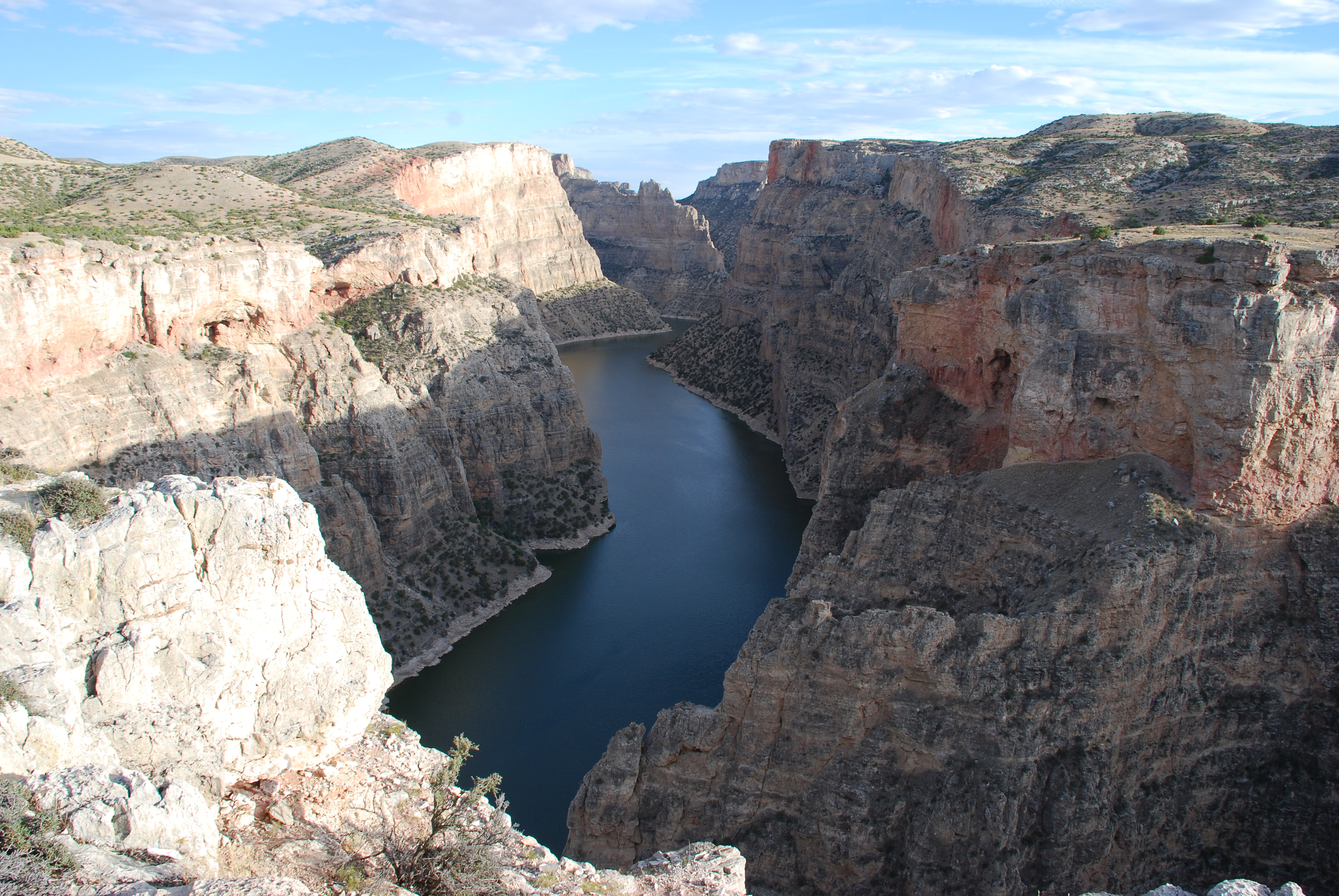
Spanning the border between northern Wyoming and southern Montana, Bighorn Canyon National Recreation Area preserves a landscape of staggering scale and profound silence. Often described as a "vertical wilderness," the recreation area is centered on Bighorn Lake, a 71-mile-long reservoir formed by the Yellowtail Dam. Here, the Bighorn River has carved a dramatic path through layers of limestone, creating sheer cliffs that rise over 1,000 feet above the water’s surface. Covering over 120,000 acres, the park is a study in geological drama and ecological diversity, offering a sanctuary for both wildlife and those seeking a true escape into the wild.
The park is divided into two distinct districts that are separated by a three-hour drive, each offering a unique perspective on the canyon. The South District, near Lovell, Wyoming, is characterized by colorful red-rock badlands and expansive desert vistas. The North District, near Fort Smith, Montana, features the massive Yellowtail Dam and the deepest, most narrow sections of the canyon. Beyond the spectacular scenery, Bighorn Canyon is a landscape of deep time, containing archaeological evidence of human presence dating back more than 10,000 years. From the ancient "Bad Pass Trail" used by Indigenous groups to the historic ranches of the 19th century, the park tells a continuous story of human adaptation to a rugged and beautiful environment.
Visiting Bighorn Canyon is an invitation to immerse yourself in the elemental forces of nature. Whether you are skimming across the turquoise waters of the lake in a powerboat, watching a herd of bighorn sheep navigate a seemingly impossible cliff face, or hiking to a remote overlook at sunset, the park provides a sense of discovery and awe. It is a place where the air is clear, the horizons are vast, and the power of the natural world is visible in every layer of stone.
Key Highlights
- Bighorn Lake: Navigate 71 miles of spectacular waterway, winding through narrow canyons and expansive basins that offer world-class boating and fishing.
- Devil Canyon Overlook: Witness one of the most iconic views in the park, where the canyon walls drop vertically over 1,000 feet to the river below.
- Bighorn Sheep and Wild Horses: Spot iconic western wildlife, including the park’s namesake bighorn sheep and the resilient Pryor Mountain wild horses.
- Yellowtail Dam: Visit the 525-foot-tall concrete arch dam that transformed the Bighorn River and created the recreation area’s massive reservoir.
- Historic Ranches: Explore the remains of 19th and early 20th-century life at the Ewing-Snell, M L, and Caroline Lockhart ranches, preserved in the South District.
- Sullivan’s Knob Trail: Hike this moderate 1.5-mile trail for unique geological features and panoramic views of the canyon and the Sykes Mountain area.
- Bad Pass Trail: Walk segments of the 10,000-year-old prehistoric route used by Native Americans to travel between the Bighorn Basin and the mountains.
Getting There
Bighorn Canyon is composed of two districts that are not connected by an internal park road. To travel between them, visitors must drive around the Pryor Mountains, a journey that takes approximately three hours.
South District (Lovell, WY):
- By Car: From Billings, MT, take I-90 west to Exit 434 (Laurel). Turn onto US 310 East/US 212 South. Follow US 310 East through the towns of Deaver and Frannie to Lovell. The Cal S. Taggart Bighorn Canyon Visitor Center is on the east side of Lovell.
- Main Access: The primary road into the South District is Highway 37, which leads to trailheads, ranches, and Horseshoe Bend.
North District (Fort Smith, MT):
- By Car: From Billings, MT, take I-90 south to Exit 495 (Hardin). Turn onto State Highway 313 and follow it south through St. Xavier to the town of Fort Smith.
- Main Access: Follow the signs through Fort Smith to reach the Yellowtail Dam Visitor Center and the Ok-A-Beh Marina.
Nearest Airports:
- Billings Logan International Airport (BIL): The primary gateway for the region, located approximately 1.5 hours from the North District and 2 hours from the South District.
- Yellowstone Regional Airport (COD): Located in Cody, WY, about 1 hour and 15 minutes from the South District.
Public Transit: There is no public transportation to or within either district of Bighorn Canyon. A personal or rental vehicle is essential for visiting the various overlooks, trailheads, and boat launches.
For detailed maps and current road conditions, visit the official park directions page.
Best Time to Visit
Bighorn Canyon experiences a semi-arid to high-desert climate, with significant temperature variations throughout the year.
Spring (April - June): Spring is a season of awakening. The desert wildflowers, including the prickly pear cactus, begin to bloom, and the bighorn sheep are often seen with their lambs. Temperatures are generally mild (60s and 70s), but high winds and occasional late-season snowstorms are possible. This is an excellent time for hiking the low-elevation trails in the South District.
Summer (July - August): This is the peak season for water recreation. Temperatures are frequently in the 80s and 90s and can exceed 100 degrees Fahrenheit. The lake provides a welcome escape from the heat. Afternoon thunderstorms are common and can produce spectacular lightning and heavy rain. It is highly recommended to start your hikes early in the morning and carry at least one gallon of water per person.
Fall (September - October): Many consider autumn to be the ideal time to visit. The intense heat of summer fades into crisp, clear days with temperatures in the 60s and 70s. The humidity is low, and the visibility for sightseeing at the overlooks is exceptional. The crowds thin out after Labor Day, providing a more peaceful experience.
Winter (November - March): Winter turns the canyon into a solitary and starkly beautiful landscape. Daytime temperatures are typically in the 20s and 30s, and nights can be well below zero. While the main roads are usually plowed, travel can be difficult due to wind chill and drifting snow. The Cal S. Taggart Visitor Center in Lovell operates on a Tuesday-through-Saturday schedule during this season.
Operating Hours: The park grounds and boat launches are open 24 hours a day, year-round. Visitor center hours are seasonal; the Yellowtail Dam center (North) is open only from Memorial Day to Labor Day.
Activities and Adventures
Bighorn Canyon offers a wide range of recreational opportunities that cater to both adventure seekers and those looking for a scenic drive.
Boating and Water Sports: The 71-mile reservoir is the park's primary attraction. With multiple marinas and boat launches (Ok-A-Beh in the North and Horseshoe Bend in the South), visitors can enjoy powerboating, sailing, and jet skiing. For a quieter experience, kayaking and canoeing the narrow canyon sections of the North District are world-class.
Fishing: Bighorn Lake is a premier destination for freshwater anglers. The lake is home to walleye, brown trout, rainbow trout, and catfish. The Afterbay area below the dam is famous for its trout fishing. A valid Wyoming or Montana fishing license is required depending on where you are on the lake.
Hiking: The park features over 15 maintained trails, mostly in the South District. The Sykes Mountain Trail and the Sullivan's Knob Trail offer moderate to strenuous hikes with incredible views. For a history-focused walk, explore the grounds of the Caroline Lockhart Ranch or follow segments of the ancient Bad Pass Trail.
Wildlife Watching: The recreation area is one of the best places in the U.S. to see bighorn sheep in their natural habitat. They are frequently seen near the canyon rims and along Highway 37. The Pryor Mountain Wild Horse Range, located on the park's western edge, is home to a unique herd of wild horses with Spanish ancestry.
Historic Ranch Tours: The South District protects four historic ranches that provide insight into the 19th-century western ranching way of life. The M L Ranch and the Ewing-Snell Ranch are easily accessible and feature preserved log buildings and corrals that tell the story of the "Cattle Kings" and early homesteaders.
Photography: Bighorn Canyon is a paradise for photographers. The contrast between the deep blue water and the towering red and tan limestone walls provides endless inspiration. The "golden hour" at Devil Canyon Overlook is a "must-do" for any photographer visiting the region.
Junior Ranger Program: Children can participate in an educational program that teaches them about the geological layers of the canyon and the history of the Bighorn River. Completing the activities earns them a Junior Ranger badge.
History & Significance
The story of Bighorn Canyon is a multi-layered narrative of geology, engineering, and human endurance.
Geological Formation: The canyon was created over millions of years as the Bighorn River cut through the Bighorn and Pryor Mountains. The sheer cliffs expose a spectacular record of Earth's history, from the Madison Limestone formed in ancient seas 300 million years ago to the colorful Chugwater Formation seen in the South District.
The Bad Pass Trail: This prehistoric route is one of the most significant archaeological features in the park. For thousands of years, Native Americans utilized this trail to bypass the rugged Bighorn Canyon while traveling between the Bighorn Basin and the Montana plains. The trail is marked by hundreds of "cairns" (rock piles) and remains a site of deep cultural importance.
Yellowtail Dam and Reservoir: Completed in 1966, the Yellowtail Dam is a masterpiece of modern engineering. Named after Crow tribal leader Robert Yellowtail, the dam was built to provide irrigation, hydroelectric power, and flood control. The creation of Bighorn Lake transformed the treacherous Bighorn River into the recreational resource it is today.
Ranching and the Frontier: In the late 1800s, the Bighorn Basin was a rugged frontier. The ranches preserved in the park, such as the Ewing-Snell and the Lockhart, represent the era of the open range and the subsequent transition to smaller, family-owned operations. Caroline Lockhart, a famous journalist and novelist, established her ranch here in the 1920s, seeking a life of independence in the wild canyon country.
Lodging and Camping
Bighorn Canyon offers several ways to stay overnight, ranging from developed campgrounds to remote backcountry sites.
In-Park Camping:
- Horseshoe Bend Campground (South District): Features sites for both tents and RVs, offering easy access to the boat launch and beach.
- Afterbay Campground (North District): Located near the Bighorn River below the dam, popular with anglers.
- Boat-In Camping: For a unique experience, several primitive campgrounds are located along the shoreline of Bighorn Lake, accessible only by water. These offer unparalleled solitude and access to the canyon.
Nearby Accommodations:
- Lovell, WY: Located adjacent to the South District, offering several motels, guesthouses, and restaurants.
- Fort Smith, MT: A small community near the North District, primarily catering to anglers with several fishing lodges and guesthouses.
- Hardin, MT: Located 45 miles north of the North District, providing a wider range of hotels and services.
Dining: There are no full-service restaurants within the recreation area. Lovell and Hardin offer numerous dining options. It is highly recommended to bring a picnic lunch and plenty of water for your day in the park.
Essential Information
Park Fees and Passes
- Entrance Fee: There is no fee to enter Bighorn Canyon National Recreation Area.
- Boat Launch Fee: A fee is required for all motorized vessels launching into Bighorn Lake. You can purchase a daily or annual pass at the visitor centers or at the launch sites.
- Camping Fees: A fee is required for overnight stays in the park's developed campgrounds.
Safety Considerations
- Heat and Hydration: The high-desert sun is intense. Carry and drink more water than you think you need. Dehydration is a serious risk.
- Water Safety: Always wear a life jacket (PFD) when on Bighorn Lake. The water is deep and can become very choppy in high winds. Be aware of submerged rocks and floating debris.
- Rattlesnakes: Prairie rattlesnakes are native to the area. Watch where you step, especially in tall grass or near rock ledges.
- Remote Locations: Cell service is extremely limited throughout the park. If you are heading into the backcountry or onto the lake, ensure someone knows your plans.
- Severe Weather: Summer storms can be violent. If you see lightning or hear thunder, return to your vehicle or seek shelter immediately.
Services and Facilities
The Cal S. Taggart Visitor Center in Lovell is fully accessible and includes a museum and theater. Most major overlooks, including Devil Canyon, are wheelchair accessible. Several trails have accessible sections, though many of the backcountry trails have uneven and rocky terrain.
Contact
- Phone: 307-548-5406
- Email: [email protected]
- Official site: https://www.nps.gov/bica/index.htm
Bighorn Canyon National Recreation Area is a place of profound beauty and hidden history. Whether you are gazing down into the depths of the canyon from an overlook or exploring the silent remains of a frontier ranch, the park provides a moving and unforgettable western experience. It is a destination that rewards the adventurous and provides a lasting connection to the wild heart of the American West.
Park Overview
Detailed overview of the park's history, geography, and main attractions will go here. This section provides essential background information for visitors.
Top Hikes
- Iconic Summit TrailDifficulty: Strenuous • Distance: 8 miles round trip
Loading reviews…
- Waterfall LoopDifficulty: Moderate • Distance: 3 miles loop
Loading reviews…
- Lakeside WalkDifficulty: Easy • Distance: 1.5 miles out & back
Loading reviews…
Recommended Hiking Gear
Gear up for your adventure with our trusted partners. These items help support the site at no extra cost to you!
Places to Stay
- Historic Park LodgeBook early!Type: Lodge
Loading reviews…
- Riverside CampgroundReservations required.Type: Campground
Loading reviews…
- Gateway Town Hotel15 miles from entrance.Type: Nearby Hotel
Loading reviews…