Captain John Smith Chesapeake National Historic Trail
Fast Facts
Captain John Smith Chesapeake National Historic Trail
Stretching across 3,000 miles of the Chesapeake Bay and its great tributary rivers, the Captain John Smith Chesapeake National Historic Trail is America’s first national water trail. Established in 2006, the trail corridor spans six states—Virginia, Maryland, Delaware, Pennsylvania, New York, and West Virginia—and the District of Columbia. It follows the routes of Captain John Smith’s historic voyages in 1607 and 1608, during which he mapped the bay and documented hundreds of American Indian communities. However, the trail is far more than a maritime history lesson; it is a living connection to the "world of water" that has sustained human societies for over 10,000 years.
The trail invites modern explorers to see the Chesapeake through the eyes of its earliest inhabitants and the English colonists. Along its winding path, visitors can experience a variety of landscapes, from the expansive open waters of the bay to the tight, cypress-lined creeks of the Eastern Shore. The trail highlights the sophisticated societies of the Powhatan, Nanticoke, and Susquehannock peoples, whose sacred sites and ancestral homelands are now recognized as archaeological treasures. By paddling these waters, you are traversing a landscape that, in many places, remains startlingly similar to the one Smith described in his journals over four centuries ago.
Visiting the Captain John Smith Chesapeake Trail is an invitation to engage with the natural and cultural heart of the Mid-Atlantic. Whether you are kayaking the gentle reaches of the Susquehanna River, exploring the re-created American Indian towns at Jamestown Settlement, or birdwatching in the sprawling marshes of Blackwater National Wildlife Refuge, the trail offers a sense of vastness and continuity. It is a place where the rhythmic pull of the tide and the legacy of ancient communities remind visitors of the enduring importance of environmental stewardship and cultural respect in the nation's largest estuary.
Key Highlights
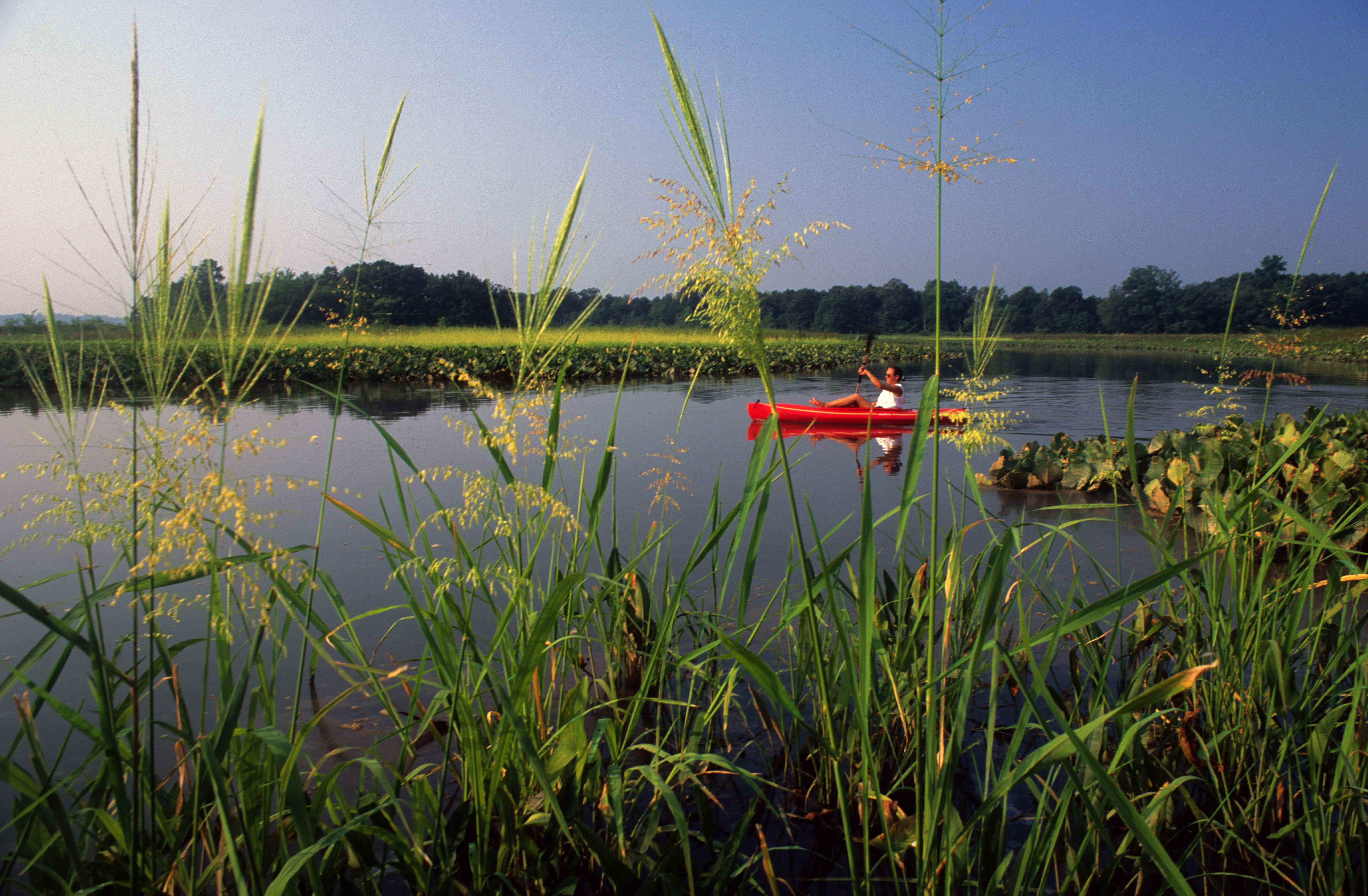
- A 3,000-Mile Water Trail: Experience the ultimate paddling adventure across the Chesapeake Bay watershed, offering thousands of launch points and diverse water conditions.
- Historic Jamestowne: Visit the trail’s headquarters and the site of the first permanent English settlement, where the voyages of John Smith began in 1607.
- American Indian Landscapes: Discover the ancestral homelands and sacred sites of the Indigenous people who have thrived in the Chesapeake region for millennia.
- Werowocomoco: Learn about the site of the principal residence of Powhatan, the powerful leader of the Tsenacommacah paramount chiefdom.
- Paddling and Boating: Explore numerous segments of the trail designed for canoes, kayaks, and small motorized vessels, with detailed "Smart Maps" available for navigation.
- Wildlife and Birding: Spot ospreys, bald eagles, great blue herons, and numerous migratory waterfowl that rely on the bay's rich riparian ecosystems.
- Chesapeake Bay Gateways: Access the trail through a network of over 170 partner sites, including state parks, wildlife refuges, and maritime museums.
Getting There
Because the Captain John Smith Chesapeake Trail is a 3,000-mile network rather than a single location, access is available through hundreds of entry points throughout the Chesapeake Bay watershed.
Main Headquarters and Visitor Center:
- Historic Jamestowne: Located at 1368 Colonial Parkway, Jamestown, VA 23081. This is the primary contact point for trail orientation and maps. It is easily reached via I-64 and the Colonial Parkway.
Regional Access Points:
- Virginia: Access the trail at Yorktown, Gloucester Point, or along the James, York, and Rappahannock Rivers.
- Maryland: Major hubs include Annapolis, the Inner Harbor in Baltimore, and numerous sites on the Eastern Shore like the Zimmerman Center for Heritage on the Susquehanna.
- District of Columbia: Launch points are available along the Anacostia and Potomac Rivers within the city.
- Pennsylvania/New York: Access the northern reaches of the trail along the Susquehanna River corridor.
Nearest Airports:
- Richmond International Airport (RIC): Convenient for the southern end of the trail near Jamestown and Yorktown.
- Baltimore/Washington International (BWI): Centrally located for Maryland and D.C. access points.
- Ronald Reagan Washington National (DCA): Ideal for exploring the trail within the nation’s capital.
Public Transit: While some urban segments of the trail (like in Baltimore, D.C., and Alexandria) are accessible via Metro or bus, a personal or rental vehicle is necessary for reaching most of the trail's remote launch points and state park partners.
Navigation Tip: The trail is primarily a water trail. Visitors should utilize the "Chesapeake Bay Gateways" map and the trail's official "Paddler’s Guide" to find designated boat ramps and soft-launch sites.
For more detailed maps and coordinates for hundreds of launch points, visit the official park directions page.
Best Time to Visit
The Chesapeake Bay watershed experiences four distinct seasons, each offering a different environment for water-based exploration.
Spring (April - June): This is a season of awakening on the trail. Migratory birds like ospreys return to the bay to nest, and the riparian forests are a vibrant green. Temperatures are generally mild (50s to 70s), making it an ideal time for long paddling trips. However, spring can be windy and water temperatures remain cold through May.
Summer (July - August): Summer is the peak season for recreational boating and swimming. The weather is hot and often humid, with temperatures reaching the 90s. The calm mornings are perfect for paddling, but afternoon thunderstorms are a frequent hazard on the open water. Be prepared for high humidity and biting insects in the marshy areas.
Fall (September - November): Many consider autumn to be the best time to experience the trail. The air is crisp and clear, and the fall foliage along the riverbanks is spectacular. The humidity drops, and the mosquitoes disappear. This is also the peak season for seeing migratory waterfowl arrive in the bay.
Winter (December - March): Winter turns the trail into a quiet and solitary landscape. While the water remains open in many parts of the bay, freezing temperatures and high winds make water-based travel dangerous for all but the most experienced and well-equipped paddlers. Winter is an excellent time for visiting the land-based museum partners and birdwatching from the shore.
Operating Hours: The water trail is technically open 24 hours a day year-round. However, access points—such as state parks and boat ramps—have their own specific operating hours and seasonal closures. Always check the status of your intended launch point before heading out.
Activities and Adventures
The Captain John Smith Chesapeake Trail is designed for active engagement with the region’s waterways and history.
Paddling (Kayaking and Canoeing): This is the heart of the trail experience. The trail offers segments suitable for all skill levels, from the sheltered "water trails within the trail" on the Eastern Shore to the challenging open-water crossings of the main bay. Detailed maps help paddlers find campsites, supply points, and points of historical interest.
Boating and Sailing: The trail is equally accessible to small powerboats and sailboats. Navigating the same channels used by Smith's shallop (an open boat) in 1608 provides a unique perspective on the scale of his achievement and the complexity of the bay’s geography.
Land-Based Exploration: For those who prefer to stay dry, hundreds of partner sites offer hiking trails, museums, and historic sites. A visit to Jamestown Settlement or the Museum of the Choptank River provides deep context for the Indigenous and colonial history of the trail.
Wildlife Watching: The Chesapeake is a world-class birding destination. Use the trail to reach remote marshes where you can see ospreys diving for fish, bald eagles nesting in loblolly pines, and thousands of tundra swans in the winter. The bay’s waters are also home to blue crabs, oysters, and various ray and shark species.
Fishing: Angling is a way of life on the Chesapeake. The trail provides access to premier spots for catching striped bass (rockfish), red drum, perch, and bluefish. A valid saltwater fishing license from the relevant state (VA, MD, etc.) is required.
Junior Ranger Program: Children can participate in an educational program that focuses on navigation, Chesapeake Bay ecology, and the history of the American Indian communities. Completing the activity booklet earns them a Junior Ranger badge.
History & Voyages
The trail tells a story of two different worlds meeting on a vast, watery frontier.
The Voyages of 1608: In June 1608, John Smith and a small crew of 14 men set out from Jamestown in a 28-foot shallop. Over two separate voyages, they traveled nearly 3,000 miles, reaching as far north as the Susquehanna River and as far east as the Nanticoke. Smith’s resulting map and "True Relation" were the first detailed accounts of the region, and they remain remarkably accurate today.
10,000 Years of Indigenous History: Long before Smith arrived, the Chesapeake was home to hundreds of American Indian communities. The bay was a highway for trade and communication. Indigenous people developed sophisticated methods of fishing, farming, and forest management. The trail highlights the resilience of these cultures, many of whom still live in the region today and maintain their traditional connections to the water.
The "shallop" and Navigation: Smith's voyage was a feat of endurance and navigation. The crew had to row and sail against tides and currents, often in unpredictable weather. They had to negotiate with diverse tribal groups, some of whom were welcoming and others who were suspicious of the newcomers. The trail allows modern visitors to appreciate the physical challenges of 17th-century exploration.
Environmental Transformation: The Chesapeake Smith saw was a world of ancient forests and incredibly clear water. Over the centuries, the bay has faced significant environmental challenges. The trail serves as a platform for bay restoration efforts, encouraging visitors to become "stewards of the Chesapeake" by practicing "Leave No Trace" and supporting conservation initiatives.
Lodging and Camping
Staying along the trail requires planning, as options range from urban hotels to remote riverfront campsites.
In-Park Camping: While the National Historic Trail itself does not manage campgrounds, many of its state park partners (such as First Landing in VA or Janes Island in MD) offer developed campgrounds for tents and RVs. Several "paddle-in" primitive campsites are also available along the water trail for those on multi-day treks.
Nearby Accommodations: The trail passes through several major cities, including Richmond, Annapolis, Baltimore, and Washington D.C., all of which offer a full range of hotels and luxury inns. Smaller maritime towns like St. Michaels, Easton, and Yorktown feature charming bed and breakfasts and vacation rentals.
Dining: The Chesapeake region is famous for its seafood, particularly blue crabs and oysters. You can find everything from dockside crab shacks to award-winning waterfront dining in the bay’s many historic port towns.
Essential Information
Park Fees and Passes
- Entrance Fee: There is no fee to "enter" the National Historic Trail. However, many partner sites (state parks, museums, etc.) charge their own admission or parking fees.
- Passes: The trail headquarters at Jamestowne accepts "America the Beautiful" passes for the NPS-managed portions of that site.
Safety Considerations
- Water Safety: The Chesapeake is a powerful and unpredictable body of water. Always wear a life jacket (PFD) at all times. Be aware of your skill level and the weather forecast. Avoid the open bay in high winds.
- Hydration and Sun: The reflection from the water intensifies the sun’s rays. Drink plenty of water and wear high-SPF sunscreen and a hat.
- Biting Insects: Ticks, mosquitoes, and "no-see-ums" can be severe in the marshy areas from spring through fall. Use insect repellent and wear protective clothing.
- Respect Sacred Sites: Many Indigenous sites along the trail are culturally sensitive. Do not remove any artifacts and maintain a respectful demeanor when visiting these locations.
- Winter Hazards: Submersion in the Chesapeake’s cold winter waters can be fatal in minutes. Only expert paddlers with drysuits should attempt winter excursions.
Services and Facilities
The trail's primary visitor center at Historic Jamestowne is fully accessible. Facilities along the trail vary greatly; urban areas have full services, while remote water trail segments may have no facilities for many miles. Always plan your supply and restroom stops in advance using the trail's "Smart Maps."
Contact
- Email: [email protected]
- Official site: https://www.nps.gov/cajo/index.htm
The Captain John Smith Chesapeake National Historic Trail is a place that invites us to listen to the voices of the water and the past. By navigating its rivers and exploring its shores, visitors can gain a deeper appreciation for the complex history and fragile beauty of the American experience on the Chesapeake Bay. It is a destination of endless horizon, profound history, and enduring spirit.
Park Overview
Detailed overview of the park's history, geography, and main attractions will go here. This section provides essential background information for visitors.
Top Hikes
- Iconic Summit TrailDifficulty: Strenuous • Distance: 8 miles round trip
Loading reviews…
- Waterfall LoopDifficulty: Moderate • Distance: 3 miles loop
Loading reviews…
- Lakeside WalkDifficulty: Easy • Distance: 1.5 miles out & back
Loading reviews…
Recommended Hiking Gear
Gear up for your adventure with our trusted partners. These items help support the site at no extra cost to you!
Places to Stay
- Historic Park LodgeBook early!Type: Lodge
Loading reviews…
- Riverside CampgroundReservations required.Type: Campground
Loading reviews…
- Gateway Town Hotel15 miles from entrance.Type: Nearby Hotel
Loading reviews…