Big South Fork National River & Recreation Area
Fast Facts
Big South Fork National River & Recreation Area
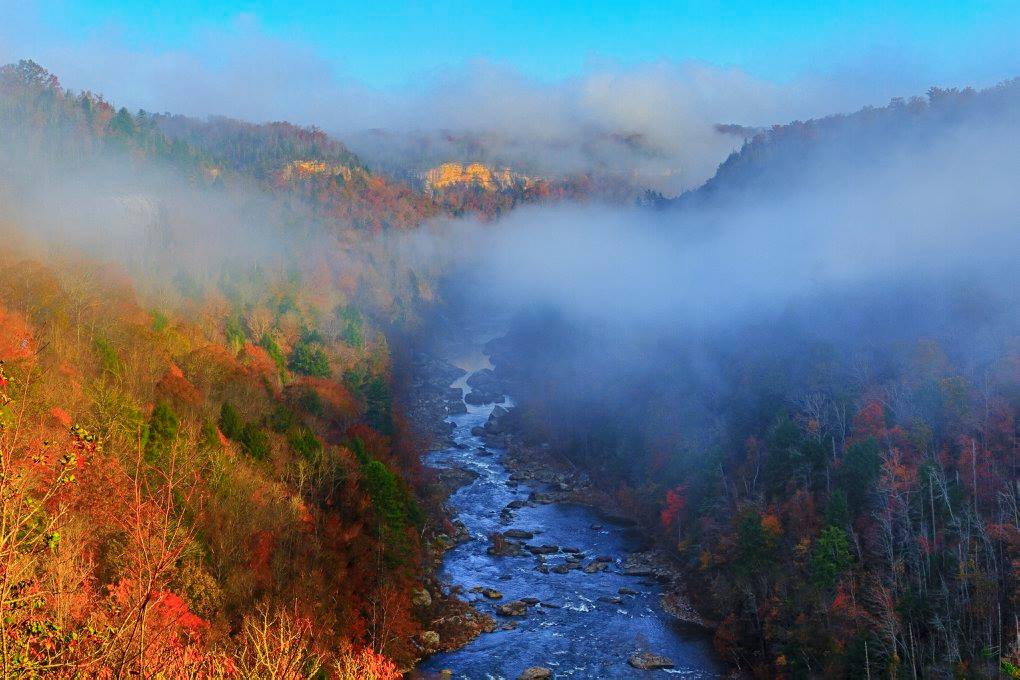
Spanning the border of north-central Tennessee and south-central Kentucky, Big South Fork National River & Recreation Area protects 125,000 acres of some of the most rugged and beautiful terrain on the Cumberland Plateau. This sprawling park is a study in vertical geology, centered on the free-flowing Big South Fork of the Cumberland River and its numerous tributaries. For millennia, these waters have carved deep, narrow gorges through the plateau’s sandstone, leaving behind a landscape defined by towering bluffs, hidden chimneys, and one of the highest concentrations of natural stone arches in the eastern United States.
Established in 1974, the recreation area was a visionary project designed to balance conservation with a high level of outdoor activity. It is a place where the industrial history of the plateau—marked by remnants of coal mining and timber harvesting—is being reclaimed by a resilient secondary forest of oak, hickory, and pine. Whether you are standing on the rim of the gorge at an overlook or paddling through the Class III and IV rapids of the river below, Big South Fork provides a sense of wildness and solitude that is increasingly rare in the eastern U.S. It is a sanctuary for diverse wildlife, including black bears, elk, and numerous rare plant species that thrive in the cool, damp microclimates of the canyon floor.
Visiting Big South Fork is an invitation to choose your own adventure. With over 500 miles of multi-use trails, it is a premier destination for hikers, mountain bikers, and equestrian enthusiasts. The park’s history is equally compelling, featuring the Blue Heron Mining Community, an outdoor "ghost town" museum that brings the era of 20th-century coal mining to life. It is a place where the natural and cultural stories of the Cumberland Plateau are preserved in every sandstone arch and silent mine shaft.
Key Highlights
- Sandstone Arches: Discover dozens of spectacular natural arches, including Twin Arches, which are among the largest and most impressive in the eastern United States.
- Paddling the Big South Fork: Experience world-class whitewater rafting and kayaking on the river, featuring challenging rapids and stunning gorge scenery.
- Blue Heron Mining Community: Explore a meticulously preserved 1930s-1960s coal mining camp, featuring "ghost structures" and immersive audio exhibits.
- Over 500 Miles of Trails: Navigate an extensive network of trails designed for hiking, mountain biking, and horseback riding, offering everything from easy rim walks to strenuous gorge descents.
- Scenic Overlooks: Witness the scale of the Cumberland Plateau from breathtaking vantage points like East Rim Overlook and Leatherwood Ford.
- Big South Fork Scenic Railway: Take a historic train ride from Stearns, KY, deep into the river gorge to the Blue Heron site.
- Equestrian Hub: Utilize some of the best horse-friendly facilities in the National Park System, including dedicated campgrounds and hundreds of miles of riding trails.
Getting There
Big South Fork is located in a remote part of the Cumberland Plateau. Because of its large size and multi-state footprint, there are several primary entry points depending on which district you wish to visit.
Tennessee District (South):
- By Car: The primary gateway is the town of Oneida, TN. From I-75, take Exit 141 (Huntsville/Oneida) and follow State Highway 63 west to US Highway 27. Proceed north on US 27 to Oneida, then follow State Highway 297 west into the park.
- Visitor Center: The Bandy Creek Visitor Center is the main contact point for the Tennessee side, located at 151 Stable Road, Oneida, TN 37841.
Kentucky District (North):
- By Car: The primary gateway is the town of Whitley City or Stearns, KY. From US Highway 27, take State Highway 92 or 1651 to reach the Stearns and Blue Heron areas.
- Visitor Center: The Stearns Visitor Center is located in the historic railroad town of Stearns, KY.
Nearest Airports:
- McGhee Tyson Airport (TYS): Located in Knoxville, TN, approximately 1.5 to 2 hours from the south entrance.
- Blue Grass Airport (LEX): Located in Lexington, KY, approximately 2 hours from the north entrance.
Public Transit: There is no direct public transportation or shuttle service to or within the recreation area. A personal or rental vehicle is necessary for your visit. The Big South Fork Scenic Railway (a seasonal commercial service) provides transportation between Stearns and Blue Heron for those interested in a rail experience.
Navigation Tip: The park’s geography is deeply dissected by the river gorge. Driving between the Tennessee and Kentucky visitor centers can take over an hour despite their proximity on a map. Plan your routes carefully.
For more detailed maps and coordinates, visit the official park directions page.
Best Time to Visit
The weather on the Cumberland Plateau is notoriously unpredictable, with four distinct seasons and significant microclimate variations between the rim and the gorge floor.
Spring (April - June): Spring is a season of transition and spectacular beauty. Wildflowers bloom throughout the hardwood forests, and the river is typically at its highest, providing the best conditions for whitewater paddling. Temperatures are mild (50s to 70s), though frequent rain showers are common.
Summer (July - August): Summers are hot and humid, with temperatures frequently reaching the 90s. The dense forest canopy provides shade for hikers, and the river offers a cool escape. Afternoon thunderstorms are very common and can move in quickly over the plateau. This is the peak season for camping and family activities.
Fall (September - October): Many consider autumn to be the ideal time for a visit. The heat of the summer fades into crisp, clear days with temperatures in the 60s and 70s. The fall foliage on the Cumberland Plateau is world-class, typically peaking in mid-to-late October. The lower water levels make the river more accessible for casual paddling and fishing.
Winter (November - March): Winter brings a quiet and somber beauty to the gorge. Temperatures can drop below freezing, and occasional snow can transform the sandstone arches into icy sculptures. While the park remains open, some roads and campgrounds may close seasonally or due to inclement weather. Winter is the best time for those seeking true solitude and unobstructed views through the leafless trees.
Operating Hours: The recreation area is open 24 hours a day, 365 days a year. Visitor centers have standard daytime hours, typically 9:00 AM to 5:00 PM, with some seasonal variations.
Activities and Adventures
Big South Fork is designed for active exploration, offering a vast array of recreational opportunities across its rugged landscape.
Hiking and Backpacking: With hundreds of miles of trails, the options are endless. The Twin Arches Loop (0.7 to 4.6 miles) is the most popular, leading to two of the largest natural bridges in the world. The Honey Creek Loop (5.5 miles) is known as one of the most rugged and rewarding day hikes in the region, featuring boulder scrambles and narrow rock passages.
Mountain Biking: Big South Fork is a premier mountain biking destination, with nearly 300 miles of trails open to bikes. The park features IMBA (International Mountain Biking Association) "Epic" rated trails that traverse the plateau and descend into the gorge. Popular routes include the Grand Gap Loop and the West Rim Trail.
Equestrian Trails: Horseback riding is a cornerstone of the Big South Fork experience. The park features nearly 200 miles of dedicated horse trails and several specialized campgrounds with stalls and washing stations. The Bandy Creek area is the primary hub for equestrian activities.
Whitewater and Paddling: The Big South Fork of the Cumberland River is a legendary whitewater destination. The "Gorge Section" features Class III and IV rapids (like "The Ell" and "Double Drop") that challenge even experienced paddlers. For a more leisurely experience, the sections above Leatherwood Ford offer gentle Class I and II water suitable for canoes and recreational kayaks.
Rock Climbing: The soaring sandstone bluffs offer numerous opportunities for traditional and sport climbing. While climbing is permitted in most areas, it is important to check for current regulations and seasonal closures designed to protect nesting raptors.
Exploring Blue Heron: A visit to the Blue Heron Mining Community is essential for understanding the region’s human history. You can walk through the "ghost structures" that sit on the footprints of original buildings and listen to the oral histories of the people who lived and worked in the mine.
Fishing and Hunting: The river is home to a variety of fish, including smallmouth bass, walleye, and muskie. Hunting is also permitted in designated areas of the recreation area during state-regulated seasons, making it a popular destination for sportsmen.
History & Heritage
The story of Big South Fork is a narrative of the Cumberland Plateau’s transition from an industrial frontier to a protected wilderness.
Sandstone Geology: The plateau is composed of Pennsylvanian-aged sandstone, siltstone, and shale. Over millions of years, the river and its tributaries have utilized the natural joints and cracks in the sandstone to erode the deep gorges we see today. The natural arches are formed through a process of "differential weathering," where softer layers of rock erode more quickly than the harder sandstone above.
The Era of Coal and Timber: In the late 19th and early 20th centuries, the Big South Fork region was heavily utilized for its natural resources. The Stearns Coal and Lumber Company was the dominant force, building company towns like Blue Heron and Stearns and constructing an extensive network of narrow-gauge railroads to haul coal and timber out of the gorge. This era shaped the culture and economy of the region for generations.
The Road to Protection: By the mid-1960s, much of the virgin timber had been cut and many of the mines had closed. A proposal to dam the Big South Fork at Devils Jumps was defeated by a coalition of conservationists and local residents. In 1974, Congress authorized the creation of the National River & Recreation Area, marking a shift toward the preservation of the river’s free-flowing character and the restoration of the forest.
Indigenous Presence: Long before European settlers arrived, Indigenous groups, including the Cherokee and Shawnee, utilized the plateau for hunting and gathering. Numerous rock shelters throughout the park contain archaeological evidence of these early inhabitants, who found refuge and resources in the deep canyons.
Lodging and Camping
Big South Fork offers a wide range of options for staying overnight, from developed campgrounds to primitive backcountry sites.
In-Park Camping:
- Bandy Creek Campground (TN): The largest developed campground, offering sites for tents and RVs with full hookups, as well as a swimming pool and playground.
- Blue Heron Campground (KY): A developed campground near the mining community, offering water and electric hookups.
- Equestrian Campgrounds: Station Camp (TN) and Bear Creek (KY) are designed specifically for horse campers.
- Backcountry Camping: Permitted throughout most of the park with a valid permit. This is the best way to experience the deep solitude of the gorge.
Nearby Accommodations:
- Oneida, TN: Offers several motels, guesthouses, and restaurants.
- Stearns and Whitley City, KY: Provide local lodging and dining options.
- Charit Creek Lodge: Located within the park and accessible only by foot, bike, or horse, this historic lodge offers a unique, full-service wilderness experience.
Dining: There are no full-service restaurants within the park boundaries (except for meals provided at Charit Creek Lodge for guests). Oneida and Whitley City offer various dining options ranging from casual cafes to national chains.
Essential Information
Park Fees and Passes
- Entrance Fee: There is no fee to enter Big South Fork National River & Recreation Area.
- Camping Fees: Vary by campground and amenities; reservations are recommended through Recreation.gov.
- Permits: A fee and permit are required for backcountry camping and for specialized activities like commercial filming.
Safety Considerations
- River Safety: The Big South Fork is a powerful and unpredictable river. Always wear a life jacket (PFD) when on the water. Be aware of your skill level and the current water levels, which can rise rapidly after rain.
- High Bluffs: The sandstone cliffs are spectacular but dangerous. Maintain a safe distance from the edges, especially in wet or icy conditions.
- Wildlife Awareness: Black bears are present. Store all food and trash in bear-resistant containers or in your vehicle. Do not approach or feed wildlife.
- Ticks and Insects: Ticks are common in the hardwood forests. Use insect repellent and check yourself thoroughly after hiking.
- Navigation: Cell service is non-existent in much of the gorge. Always carry a physical map and compass or a reliable GPS device.
Services and Facilities
The visitor centers at Bandy Creek and Stearns are fully accessible and include restrooms, bookstores, and theaters. Many of the developed overlooks and parts of the Blue Heron site are wheelchair accessible. However, the majority of the park’s hiking and biking trails are rugged and not suitable for those with mobility impairments.
Contact
- Phone: 423-569-9778
- Email: [email protected]
- Official site: https://www.nps.gov/biso/index.htm
Big South Fork National River & Recreation Area is a place where the scale of the landscape and the depth of the history provide a truly immersive experience. Whether you are navigating a whitewater rapid, exploring the silence of a sandstone arch, or reflecting on the lives of the coal miners at Blue Heron, the park offers a moving and unforgettable connection to the wild soul of the Cumberland Plateau.
Park Overview
Detailed overview of the park's history, geography, and main attractions will go here. This section provides essential background information for visitors.
Top Hikes
- Iconic Summit TrailDifficulty: Strenuous • Distance: 8 miles round trip
Loading reviews…
- Waterfall LoopDifficulty: Moderate • Distance: 3 miles loop
Loading reviews…
- Lakeside WalkDifficulty: Easy • Distance: 1.5 miles out & back
Loading reviews…
Recommended Hiking Gear
Gear up for your adventure with our trusted partners. These items help support the site at no extra cost to you!
Places to Stay
- Historic Park LodgeBook early!Type: Lodge
Loading reviews…
- Riverside CampgroundReservations required.Type: Campground
Loading reviews…
- Gateway Town Hotel15 miles from entrance.Type: Nearby Hotel
Loading reviews…