Bandelier National Monument
Fast Facts
Bandelier National Monument
Perched on the eastern slopes of the Jemez Mountains in northern New Mexico, Bandelier National Monument preserves a landscape of stunning geological beauty and profound human history. Spanning over 33,000 acres of the Pajarito Plateau, the monument is a world of deep, narrow canyons and broad mesas formed by the cataclysmic eruptions of the Valles Caldera over a million years ago. For more than 11,000 years, this rugged terrain has been home to human beings, most notably the Ancestral Pueblo people who carved their homes directly into the soft volcanic tuff of the canyon walls.
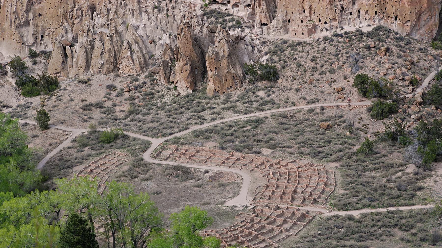
The monument is named after Adolph Bandelier, a 19th-century anthropologist who extensively studied the site and brought its significance to national attention. The heart of the park is Frijoles Canyon, where the permanent water of the Rito de los Frijoles allowed for the development of a thriving agricultural society. Here, visitors can see the remains of Tyuonyi, a massive circular village that once stood two stories tall, and the "cavates"—human-carved rooms in the cliffside that served as homes and storage spaces. Unlike many archaeological sites, Bandelier feels deeply "lived-in," offering an intimate look at the daily lives of the people who shaped this landscape.
Bandelier is more than a relic of the past; it is a living landscape that remains spiritually and culturally vital to the 23 modern Pueblos of New Mexico. The descendants of the people who built Tyuonyi and carved the cavates still call this region home, and their connection to the land is reflected in the ongoing management and preservation of the site. A visit to Bandelier is an invitation to explore the intersection of geology and culture, and to reflect on the enduring resilience of the human spirit in a challenging environment.
Key Highlights
- The Main Loop Trail: Walk the 1.2-mile paved path through the floor of Frijoles Canyon, passing the Tyuonyi village ruins and numerous accessible cavates.
- Alcove House: Climb 140 feet up a series of four wooden ladders to reach this spectacular cliff dwelling, formerly known as Ceremonial Cave, located 1.5 miles from the visitor center.
- Long House: Observe a nearly 800-foot-long section of the cliff base where multi-story masonry dwellings were built against the rock face.
- Tyuonyi Village: Explore the foundations of a circular pueblo that once contained over 400 rooms and served as the community’s social hub.
- Tsankawi Unit: Visit the detached unit of the monument, featuring unexcavated ruins, narrow footpaths worn deep into the rock, and numerous petroglyphs.
- Frijoles Canyon Vistas: Hike the Frey Trail for a panoramic bird’s-eye view of the canyon floor and the ruins from the mesa top.
- Petroglyphs and Pictographs: Discover ancient rock art throughout the park that depicts animals, celestial events, and the spiritual symbols of the Ancestral Puebloans.
Getting There
Bandelier National Monument is located in northern New Mexico, approximately 45 miles northwest of Santa Fe and 12 miles from Los Alamos.
By Car:
- From Santa Fe: Follow US Highway 84/285 north to Pojoaque. Exit west onto NM Highway 502 toward Los Alamos. Take the NM Highway 4 exit toward White Rock and Bandelier. Proceed approximately 12 miles to the monument entrance on the south side of the road.
- From Los Alamos: Follow NM Highway 4 south and east for approximately 12 miles to the park entrance.
- Main Entrance: The physical address is 15 Entrance Road, Los Alamos, NM 87544.
The Shuttle System: To manage congestion in Frijoles Canyon, the monument typically requires visitors to use a mandatory shuttle bus during the peak season (usually mid-May through mid-October). The shuttle departs from the White Rock Visitor Center. Private vehicles are generally permitted only before 9:00 AM or after 3:00 PM during this period.
Nearest Airports:
- Santa Fe Regional Airport (SAF): Located about 1 hour from the monument, offering regional flights.
- Albuquerque International Sunport (ABQ): The nearest major international hub, approximately 2 hours to the south.
Note on Communications: Bandelier is in a remote location. Cell service within Frijoles Canyon is extremely limited and generally only available to Verizon customers. It is important to download maps and arrange for transportation (if using a ride-share) before entering the canyon.
For detailed shuttle schedules and seasonal regulations, visit the official park directions page.
Best Time to Visit
The Pajarito Plateau experiences a high-altitude climate with four distinct seasons and significant temperature variations.
Spring: Spring is a season of transition. Temperatures in the 70s can be followed by sudden snowstorms with highs in the 40s. While unpredictable, spring is a beautiful time for hiking as the desert flora begins to bloom.
Summer: Summer is the most popular time to visit. June is typically the hottest month, with dry heat often reaching the 90s. In late July and August, the "monsoon" season begins, bringing dramatic afternoon thunderstorms and the potential for flash flooding. If you visit in summer, plan your ladder climbs and hikes for the early morning to avoid the heat and the risk of lightning.
Fall: Many regular visitors consider autumn to be the ideal season. The days are usually sunny and mild, with crisp, clear nights. The cottonwood trees along the Rito de los Frijoles turn a brilliant yellow, creating a stunning contrast with the red rock and blue sky.
Winter: Winter brings a quiet and somber beauty to the canyon. The monument receives an average of 25 inches of snow annually. While the main loop trail is usually kept clear, higher-elevation trails may be closed due to snow and ice. The visitor center remains open, offering a warm refuge and a different perspective on the ruins.
Operating Hours: The monument is open daily from sunrise to sunset. The visitor center and museum are open from 9:00 AM to 5:00 PM. The site is closed on Christmas Day.
Activities and Adventures
Bandelier offers a wide range of activities for history buffs, hikers, and families alike.
Frijoles Canyon Hiking: The 1.2-mile Main Loop Trail is a must-do for every visitor. It is paved and relatively level, making it accessible to many. For a more adventurous extension, continue another half-mile to the Alcove House, where you can climb the ladders to stand in a high-elevation alcove once used for ceremonies.
Wilderness Exploration: Beyond the main ruins, over 70 miles of trails traverse the Bandelier Wilderness. Routes like the Falls Trail take you past spectacular waterfalls to the Rio Grande, while the Cerro Grande Trail leads to the highest point in the monument at over 10,000 feet, offering views of the Valles Caldera.
Tsankawi Exploration: For those looking for a more rugged and less crowded experience, the Tsankawi Unit is highly recommended. The 1.5-mile loop trail involves climbing several wooden ladders and walking along ancient paths worn deep into the volcanic tuff mesa.
Stargazing: Bandelier's remote location and high altitude make it an excellent place for astronomy. The park periodically hosts night sky programs with telescopes and ranger talks. The lack of light pollution reveals the Milky Way in incredible detail.
Junior Ranger Program: Children can participate in an educational program that teaches them about Puebloan culture, the importance of water in the desert, and how to protect archaeological sites. Completing the activities earns them a Junior Ranger badge.
Museum and Film: The visitor center features a high-quality museum with artifacts found in the canyon and a film that provides the historical and cultural context of the monument. It is an essential first stop for understanding the site’s significance.
History & Culture
The story of Bandelier is a 1.25-million-year narrative of geology and human endurance.
The Volcanic Foundation: The landscape of Bandelier was created by two massive eruptions of the Valles Caldera. These events deposited hundreds of feet of volcanic ash, which compressed over time into a soft rock called tuff. The erosion of this tuff created the vertical cliffs and the natural holes (pockmarks) that the Ancestral Puebloans utilized to start their dwellings.
Ancestral Puebloan Life (1150 - 1550 CE): The people who lived in Frijoles Canyon were master farmers, growing corn, beans, and squash on the mesa tops. They utilized the cavates for warmth in the winter and coolness in the summer. Their society was highly organized, centered around the Tyuonyi pueblo and numerous kivas (ceremonial chambers).
The Great Migration: Around 1550 CE, a combination of drought and changing social factors led the people of Bandelier to migrate toward the Rio Grande valley. They didn't "disappear"; they are the direct ancestors of the modern Cochiti, San Ildefonso, and Santa Clara Pueblos. To these communities, Bandelier is not a "ruin" but a place where the spirits of their ancestors still reside.
Archaeology and Protection: Bandelier was established as a National Monument by President Woodrow Wilson in 1916. During the 1930s, the Civilian Conservation Corps (CCC) built much of the current infrastructure, including the visitor center and the beautiful lodge buildings, which are now a National Historic Landmark.
Lodging and Camping
Bandelier offers several options for those looking to stay in the rugged canyon country.
In-Park Camping:
- Juniper Campground: Located near the park entrance, this campground offers 57 sites for tents and RVs (no hookups). It is open year-round and operates on a first-come, first-served basis, though some sites can be reserved through Recreation.gov.
- Ponderosa Campground: A smaller campground located at a higher elevation, suitable for groups and open seasonally.
Backcountry Camping: Camping is allowed in the Bandelier Wilderness with a permit, which must be obtained at the visitor center. This is a fantastic way to experience the solitude of the Pajarito Plateau.
Nearby Accommodations: The towns of White Rock and Los Alamos offer several hotels, motels, and bed and breakfasts. Santa Fe, a one-hour drive away, provides a vast array of world-class lodging and dining options.
Dining: The Sirphey at Bandelier snack bar, located near the visitor center, offers seasonal light meals and refreshments. The nearby towns of White Rock and Los Alamos have numerous restaurants and grocery stores.
Essential Information
Park Fees and Passes
- Entrance Fee: $25 per private vehicle, valid for 7 days.
- Camping Fees: Vary by campground; Juniper Campground is typically $20 per night.
- Passes: Bandelier accepts all "America the Beautiful" passes.
Safety Considerations
- Altitude: Bandelier’s elevation ranges from 6,000 to over 10,000 feet. Be aware of the signs of altitude sickness, including headache and nausea. Drink plenty of water and pace yourself.
- Heat and Hydration: The New Mexico sun is intense. Carry and drink at least one liter of water per hour when hiking in the summer.
- Ladder Safety: Climbing the ladders to Alcove House and in Tsankawi requires focus and physical effort. They are not recommended for those with a fear of heights or limited mobility.
- Lightning: Afternoon thunderstorms are common in the summer. If you hear thunder, seek shelter immediately.
- Historic Preservation: Help protect the site by not climbing on masonry walls or touching the plaster inside cavates. Do not remove any pottery shards or stones.
Services and Facilities
The Visitor Center and Museum are fully accessible and include restrooms and water fountains. The Main Loop Trail is paved and accessible to wheelchairs and strollers for the first portion, including the view of Tyuonyi. The Alcove House and Tsankawi trails are not wheelchair accessible.
Contact
- Phone: 505-672-3861
- Email: [email protected]
- Official site: https://www.nps.gov/band/index.htm
Bandelier National Monument is a place of profound power and quiet majesty. It challenges us to look beyond the surface of the landscape to see the deep layers of human history written in the cliffs. Whether you are climbing a ladder to a high alcove or sitting quietly by the Rito de los Frijoles, Bandelier offers a moving and unforgettable connection to the spirit of the Southwest.
Park Overview
Detailed overview of the park's history, geography, and main attractions will go here. This section provides essential background information for visitors.
Top Hikes
- Iconic Summit TrailDifficulty: Strenuous • Distance: 8 miles round trip
Loading reviews…
- Waterfall LoopDifficulty: Moderate • Distance: 3 miles loop
Loading reviews…
- Lakeside WalkDifficulty: Easy • Distance: 1.5 miles out & back
Loading reviews…
Recommended Hiking Gear
Gear up for your adventure with our trusted partners. These items help support the site at no extra cost to you!
Places to Stay
- Historic Park LodgeBook early!Type: Lodge
Loading reviews…
- Riverside CampgroundReservations required.Type: Campground
Loading reviews…
- Gateway Town Hotel15 miles from entrance.Type: Nearby Hotel
Loading reviews…